
Lake Superior's Water Level
Each year, Lake Superior goes through a normal fluctuation where the water level gets higher and lower. Lake levels follow a seasonal pattern, normally rising in the spring, peaking in the summer, and declining in the fall to a low during the winter. The lake level is only one factor that determines the severity of erosion. Erosion occurs regardless of how high or low the water level happens to be, especially during storms. However, some people feel that higher water levels make the erosion worse than if the levels were normal or below normal. It is interesting to note that when the lighthouse lost its entrance building to erosion in 1996, the lake level was higher than normal.
Factors Controlling Lake Superior's Water Level
Outflow from Lake Superior through the St. Marys River is regulated by the International Lake Superior Board of Control (http://ijc.org/en_/ilsbc), which was established in 1914 by the International Joint Commission (http://www.ijc.org). (The International Joint Commission was established in 1909 by the Boundary Waters Treaty between the U.S. and Canada.) They are currently using Regulation Plan 2012 to regulate the outflow of water from Lake Superior. In determining the appropriate outflow levels, the Board not only has to consider the level of Lake Superior, but must also consider the level of Lakes Michigan and Huron. Changing water levels can affect drinking water intakes, commercial shipping, hydroelectric power generation, agriculture, shoreline property, recreation, fisheries, wildlife, wetlands and other interests. In other words, determining the outflow is not something that can be easily done by just looking at the current level of Lake Superior.
Other factors that affect Lake Superior's water level are the amount of precipitation the Lake Superior Basin receives and the rate of evaporation (this depends on ice cover in the winter, temperatures, cloud cover, etc.).
Current Lake Level 
In 2012-2013 many were getting nervous about the seriously low water level of Lake Superior and whether or not the trend would reverse. Starting in April 2014, the levels went back up and were above average until August of 2021, when they went back to being average. Starting in September 2021, the level went below average. In May 2022, the level went back above average for a short time due to above normal precipation amounts for the month. In May 2026, Lake Superior's mean water level was 601.67 feet. The long term average mean water level for Lake Superior in May is 601.61 feet (average was obtained from data from 1918-2024.) This means that in May 2026, Lake Superior's water level was 0.06 feet above average for May. The May 2025 mean water level was 601.31 feet. This means it was 0.36 feet higher this year in May compared to last year. The maximum May mean ever recorded was in 2019 at 602.92 feet. According to the Army Corps of Engineer's Forecast, it looks as if the water level will be close to average through October 2026. This data was obtained from the U.S. Army Corps of Engineers' web site.
To visit the U.S. Army Corps of Engineers Detroit District's web site for water levels and forecasts, click the following links:
Ground Cover
Ground cover helps to prevent some erosion by trapping windblown sand or preventing sand from blowing away. Indigenous (native) plants such as beach grasses are very important for this purpose and are best suited for this role. It is more likely that native plants will be able to survive the harsh conditions at Crisp Point. Please do not disturb beach grasses at Crisp Point and please do not plant any non-native species that could be exotic to the area or could bring unwanted insects or diseases. Also please do not plant trees on the property that could potentially block future views of the lighthouse, cause access issues for restoration or erosion control projects, or cause damage to the boardwalk, visitor center, or lighthouse from roots. Visitors must obtain permission from the CPLHS Board of Directors prior to planting any vegetation, including trees. Currently, CPLHS does not see a need to plant trees on the property, as we currently have more trees present than Crisp Point had historically. Further, our historic preservation easement dictates that CPLHS shall not permit any ground-disturbing activities which would affect any historically significant or archaeological resources without receiving prior written permission from the State Historic Preservation Office (SHPO).
ORV/ATV Damage
Off Road Vehicles (ORVs) can also contribute to environmental damage surrounding the lighthouse. For example, vegetation that is vital to keeping and trapping sand around the lighthouse tower can be killed by ORVs. Due to the harsh conditions at the site, it may take many years for the damage to be reversed. An ORV may not be operated in a manner that creates an erosive condition. Michigan's soils and shorelines are fragile, and ORV operation in these areas and along stream banks and other waterways is restricted. It is unlawful to operate any ORV in or on the waters of any stream, river, marsh, bog, wetland, swamp, or quagmire, unless you are driving on a bridge, culvert, or similar structure. For more information on ORV operation in Michigan, please visit the Michigan Department of Natural Resources web site at:https://www.michigan.gov/dnr/0,4570,7-350-79119_79148---,00.html.
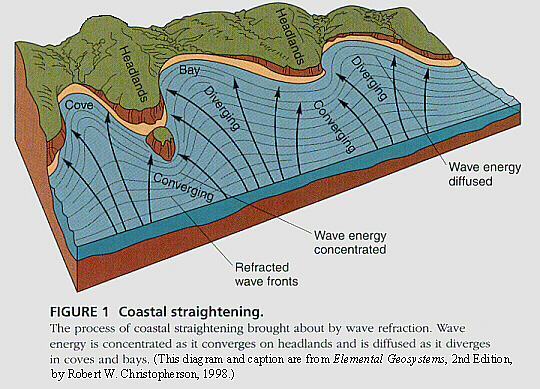
Coastal Straightening and Erosion
The process of coastal straightening is always occurring, especially during storms. Usually the worst storms that Crisp Point has to face occur in November. With coastal straightening, wave energy is concentrated on land masses that protrude into the lake, causing them to erode away and the coast to become straight. If one looks at old pictures of Crisp Point, it is easy to see that this process is definitely occurring at Crisp Point. We have had to place large boulders and stone in front of the lighthouse to protect it from Lake Superior's waves. We must keep erosion control on our minds at all times, even if things seem good now. As we learned in November of 1996, it just takes a few major storms to take back everything we've gained. To make a donation to help protect Crisp Point from erosion, see the following page: http://www.crisppointlighthouse.org/how.html.


Email us with comments about the website at info@crisppointlighthouse.org
Copyright © 2022-26 Crisp Point Light Historical Society
Last Modified June 11, 2026